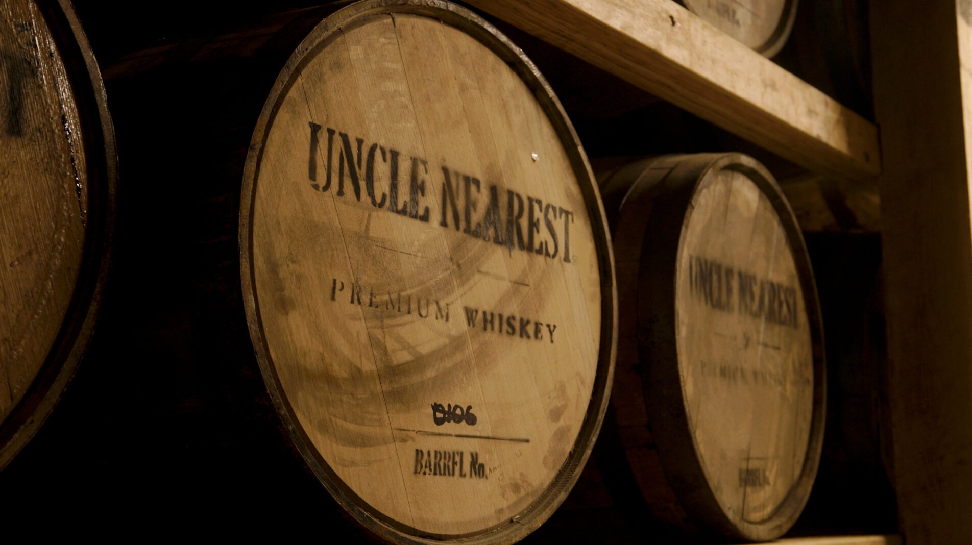
We usually only hear about Grande and Petite Champagne, Borderies, and to some extent Fins Bois Cognac. The former two are certainly the powerhouses behind the region. There are countless stories by numerous different producers about the prestige of these areas and how the grapes are superior. Science has proven that growing conditions are certainly the best in those soils. But there are also many stories to be told about Cognac that lie farther from these regions. And it all comes from the often looked down upon cru of Bois Ordinaires. This area produces the least amount of Cognac and has the smallest number of vineyards planted than any other sub region in the Cognac AOC. However, an interesting attribute of this delimited zone lies in the Atlantic Ocean. Off the west coast of France sits a cluster of islands in the Bay of Biscay. They belong to Bois Ordinaires.
At first thought, you might say that doesn’t seem right. Islands are a part of the Cognac producing region? As much as it contradicts our preconceived ideas about what Cognac is, it’s true. The location of the grapes in relation to the ocean gives them a briny, sea salt characteristic in the eau-de-vie. That’s not something most are accustomed to. Maritime influence on spirits is more akin to single malt Scotch than Cognac. But today there are a few producers that are trying to showcase the uniqueness of these islands.
While eau-de-vie has never been a large contributing factor to any of the islands’ economies, wine production has existed for quite some time. The Charentais archipelago, as it’s called, is a collection of four islands: Ré, Oléron, Aix, and Madame. Of the four islands, the largest two, Ré and Oléron, are currently cultivating Cognac grapes, among others, to make wine for distillation. But just by looking at these small coastal communities, you’d never guess the turbulent past they’ve seen. From naval battles crashing onto their shores, the Nazi invasion, and the thriving tourism of present day, there’s no shortage of excitement.
The history of these islands is vast. Below is a quick overview of the two main islands and is in no way an exhaustive chronology of their complete past.
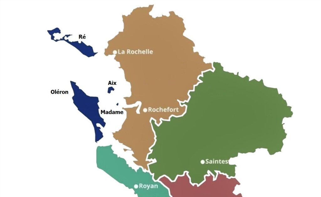
Bois Ordinaires islands in blue
• • • • •
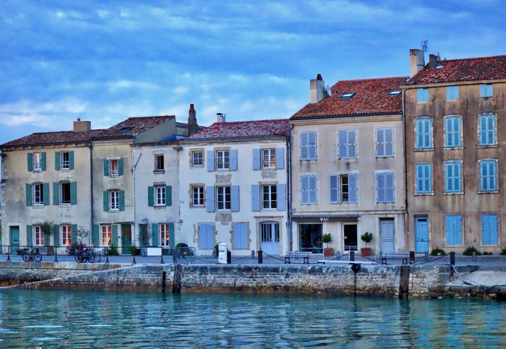
Île de Ré
The island of Ré is located near the port city of La Rochelle, to the north of the Pertuis d’Antioche strait. It has a maximum elevation of 22 meters (72 ft). Of the two bigger islands, it comes in second in terms of size. It sits right around at 30 km (19 miles) long and 5 km (3 miles) wide. The permanent residence population is around 18,000. During its peak tourism season in the summer, the number of people rises to a shocking 130,000. There are 10 small villages on the island.
Ré didn’t start out as an island, but as a group of them. Four different small islets to be exact. It was during the Roman Empire when the island we know today started to take shape. There were numerous salt fields created and silting taking place on the islands, among other human activity. That started filling in the gaps between the four separate locations. This action, combined with the natural building up of earth from the waves carrying sea floor debris, created marshlands. By around 600-700 CE, the lands were fully joined together as one.
According to Marianne Lohse of France Today Magazine, “the name Ré is derived from ratis, the word for fern in the Celtic language of ancient Gaul,” as many ferns covered the island initially. In similar fashion to other places around Europe, the church made its mark early and built a monastery on the island in 745 CE. It wasn’t long until inhabitants realized the strategic value of the island’s location. One could see a water invasion coming from some distance away. With some defenses, a small army could hold off ships before they hit mainland France.
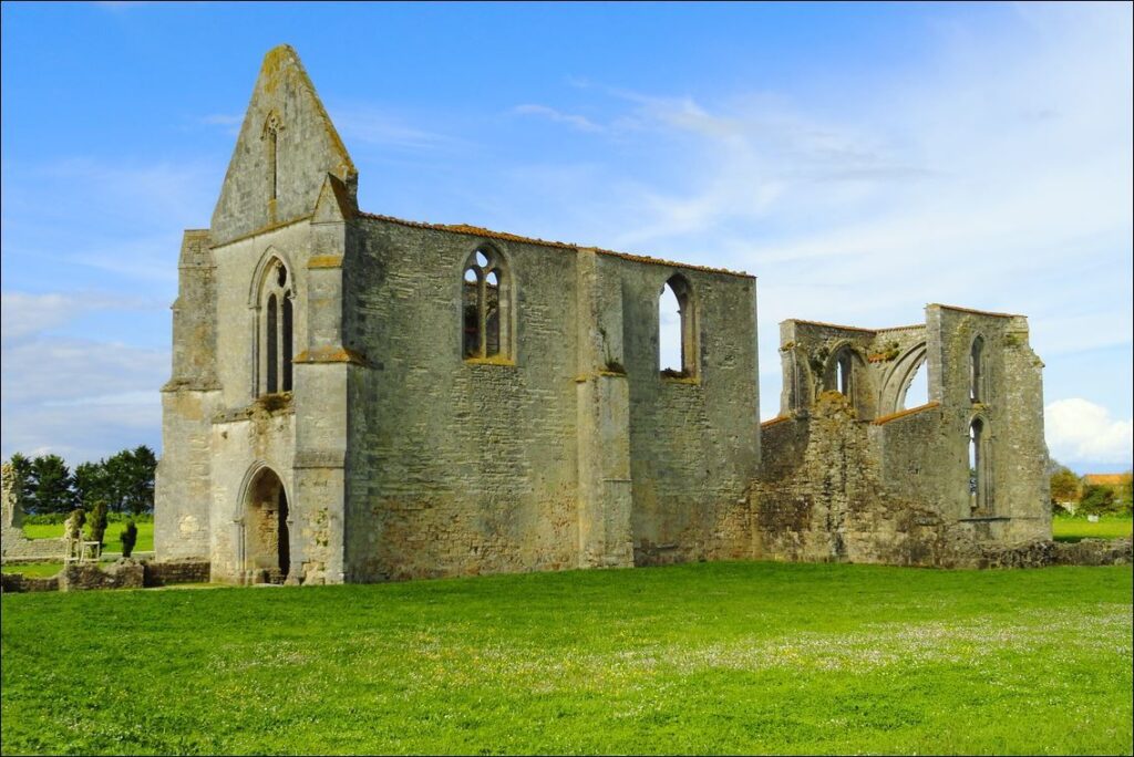
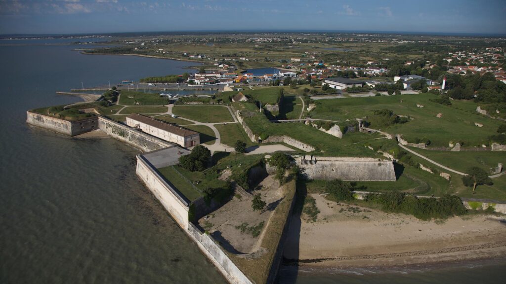
In the early 11th century, small fortifications began being constructed on the coasts of Ré. By 1154 CE, England took ownership of the island as Eleanor of Aquitaine became queen of England after marrying Henry Plantagenet. The only remaining structure on the island from this time are the ruins of the Saint-Laurent abbey, shown below. This is one of the biggest tourist attractions today.
In 1243 CE, Ré once again became French as King Henry III of England returned the island to Louis IX in a treaty agreement. This didn’t last long, however, as the Hundred Years War began in 1337 CE between England and France. Ré was constantly tossed into battle. By the end of the war, it had been attacked a handful of times and was brought to near ruins. Luckily, as the dust settled, a long stretch of relative peace remained on Ré. However, the next major attack came in 1625 CE when Huguenot’s (French Protestants) invaded. They captured the island and held it for several months. Unfortunately for them, King Louis XII aggressively attacked back and defeated them swiftly.
It was at this point that serious fortifications began to be built. After the defeat of the Huguenot’s, a fort was ordered to be immediately constructed. They called it Fort de la Prée. It was located at La Flotte on the east side of the island. It was only two years later in 1627 CE that the fort was put to the test as England attacked it and landed on Ré. The French were able to defeat them quickly thanks to the fort, but they returned one year later and tried again. This time, the English army landed on the north coast of the island at Saint-Martin-de-Ré. Still, they were no match for the French commander of Ile de Ré.
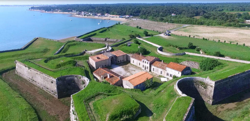
To dissuade future attacks from his enemies, King Louis XIV commissioned another fort. This time it was at Saint-Martin-de-Ré. With it, he ensured an absolute power hold for the French army. It took over four years just to build the walls that surrounded the complex. They did not take this construction lightly and spared no expense. It wasn’t completed until 1681. The intimidation factor seemed to work, as peace was returned to Ré until WWII.
In 1940, the German authorities, like so many others before them, discovered the strategic advantage of Ré. Surrounding the island with naval mines, it was protected from any possible artillery attack. The Nazi’s made the stronghold at Saint-Martin-de-Ré their operating room while building bunkers all over the coast, including around Fort de la Prée. By 1942, the island was occupied by the German navy. When the tides turned and the American army helped take back France from German control, there wasn’t much resistance left. In 1945, after several skirmishes, the Nazi commanders signed a surrender statement on May 9th. Ile de Ré was the final holdout of German forces in France before their official demise.
Today, instead of waiting for a ferry, Ré is connected to the mainland at La Rochelle by a bridge. It was built in 1988 and will cost you a few Euros to cross, however. Tourism is a huge driving force of their economy. Besides the historical attractions, you’ll find many vineyards producing local wine. Grapes have been present on the island since Roman occupation. A wine grower collective called Vignerons Uniré (winegrowers united) are the largest producers on Ré. They make red, white, and rosé wines as well as Pineau des Charente and Cognac under the label Île de Ré. It’s distilled and aged right on the island.
Most notably, Camus produces a line of Cognac’s exclusively from Ré that launched in 2012. They have three different expressions: Fine Island, Double Matured, and Cliffside Cellar, which is actually partially aged in Fort de la Prée. As one of the industry leaders in innovation, Camus was the first house to produce Cognac from grapes exclusively grown on Ré.
• • • • •
Île d’Oléron
The island of Oléron is located south of Ré and is separated from the mainland by the Pertuis de Maumusson strait. It’s the second largest French island after Corsica. Oléron has a maximum elevation of 34 meters (112 ft). The island is 30 km (19 miles) long and 8 km (5 miles) wide with a population around 22,000. There are eight different municipalities located there.
The name seems to derive from the town of Château-d’Oléron, a port city on the south eastern coast. During the Roman occupation, a fortified camp, surrounded by ramparts, was located there. This name is reported by the famous historian Pliny the Elder, who had a friend stationed there in the Roman garrison. However, if the name of that small city was then subsequently applied to the entire island, its true meaning most likely remains unknown.
The human occupation of the island was in the Neolithic era. Several archeological sites have been unearthed in the southern part of Oléron dating to that time period. By the 6th or 7th century, the island, along with Ré, were called the Vacetian Islands. A name given to them by the Basque inhabitants whom controlled the islands. As noted above, Eleanor of Aquitaine took control of Ré, but also Oléron, in 1154 CE. She returned in 1199 CE and ended up staying at the castle in Château-d’Oléron for several years until her death in 1204 CE.
Oléron returned to French control in the 13th century, but in 1306 CE, Edward I of England ruled over France and gifted the island to his son, Edward II. As the Hundred Years War began, Oléron suffered less damage and invasion than Ré, but was still a constant target nonetheless. In February of 1625 CE, after the Huguenot’s seized Ré, Oléron came next. Several months later, the Duke of Guise, a prince of French nobility, organized a landing in order to retake the island. He was supported by the Dutch and English fleets and won easily.
While fortifications were being rapidly built on Ré, King Louis XII did not overlook Oléron. In the early 17th century, a medieval castle stood in poor condition at Château-d’Oléron. The decision to build a citadel atop of it was made. This structure was later modified and enlarged by the famous military architect, Vauban. The citadel was used for the defense system of the Arsenal de Rochefort, along with Fort Louvis which was situated right off the French mainland. Any enemy ships caught coming close to Rochefort would have to cross between the fortifications and would be ripped to shreds by canon fire.
During WWII, the island was occupied by German forces. They built their bunkers and took over the citadel. However, unlike Ré, Oléron was not saved by the Americans. Instead, it had its own people to thank. It was liberated by the Free French Forces, which was a government-in-exile group led by Charles de Gaulle. As detailed in the book The French Navy In World War II by Rear Admiral Paul Auphan and Jacques Mordal (2016 ed.), the liberation consisted of an amphibious assault, code-named Operation Jupiter, on April 29th, 1945. The French cruiser, Duquesne, fired 550 heavy shells at the Nazi bunkers and command posts. The garrison surrendered on the following day (pp. 353-354).
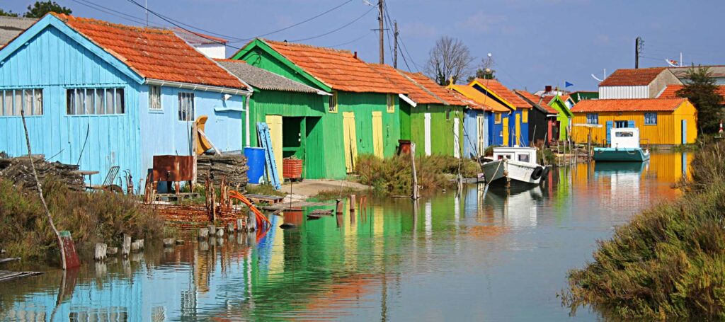
Oléron also has a bridge connecting it to mainland France. It was constructed in 1966 and it’s free of charge to cross back and forth. The island has a long history of oyster production and you can see the tiny oyster huts, painted in bright colors, all along the shores. They also prefer that you refrain from car usage and instead ride a bike. There are over 130 km of bike trails across the island.
Wine production has been active on the island since the 6th and 7th century, but some historians believe it was even earlier than that. There are over 700 hectares (1730 acres) of vines planted on the island. In 1925, the first co-operative was established for viticulture. After the 1950’s, there were five on the island. As of 1992, all of them joined together under the name Vignerons d’Oléron. According to their website, by 1820 CE, wine growing was the most important source of income on the island. Besides wine and Pineau, they also produce Cognac under the labels Boyard and Louis Pearl. There are a few other tiny producers selling their own independent labels, as well.
As far as more prominent houses go, Augier has recently released an expression called L’Océanique. It’s made from Ugni Blanc grapes grown on Oléron and contains no additives whatsoever. Very light in color, it’s a true representation of what an island Cognac can be.
Phylloxera on the Islands
Lucky enough for the islands, phylloxera didn’t have as terrible of an impact as it did throughout the rest of France. They still lost about 70% of their crops initially, but they were also still able to grow grapes in many areas. The phylloxera louse hates two things the most, sand and water. At least on the outer banks of both islands, the soil is very sandy and, as you can imagine, right by the water. The pest couldn’t live in the soil and therefore many vineyards were saved. The winegrowers on Ré and Oléron acted quickly and exploited the sandy soils.
With the destruction of many vines, the ones that were left were in high demand. Even though they weren’t of extraordinary quality, it didn’t matter. People needed their wine no matter what form it came in. Much of the uncultivated soil on the islands suddenly became devoted to growing vines. Land that, before 1860 CE, would have been worth pennies for a square meter were now fetching 3+ francs per square meter. While farmland fell in value, these plots of sandy soils kept rising in price. Also, this gave winegrowers the option to continue using Folle Blanche and Colombard, both of which still exist on the islands today. As the rest of France suffered greatly through the phylloxera outbreak, Ré and Oléron managed to stay afloat and not fall into economic turmoil.

Henry the 8- luyi 13- Jo place- thanks for the reminder- us thanks for bringing it back from the Nazis